


Precinct 31, Cochise County, Arizona
About
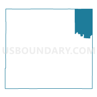
Outline

Summary
| Unique Area Identifier | 523694 |
| Name | Precinct 31 |
| County | Cochise County |
| State | Arizona |
| Area (square miles) | 410.71 |
| Land Area (square miles) | 410.65 |
| Water Area (square miles) | 0.05 |
| % of Land Area | 99.99 |
| % of Water Area | 0.01 |
| Latitude of the Internal Point | 32.24600450 |
| Longtitude of the Internal Point | -109.18752120 |
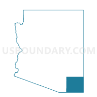
Maps

Graphs
Select a template below for downloading or customizing gragh for Precinct 31, Cochise County, Arizona


Neighbors
Neighoring Voting District (by Name) Neighboring Voting District on the Map
- Duncan Voting District, Greenlee County, AZ
- Hidalgo County Precinct 1, Hidalgo County, NM
- Hidalgo County Precinct 5, Hidalgo County, NM
- Precinct 12, Cochise County, AZ
- precinct 30, Cochise County, AZ
- Solomon 1 Voting District, Graham County, AZ
Top 10 Neighboring County Subdivision (by Population) Neighboring County Subdivision on the Map
- Safford CCD, Graham County, AZ (24,993)
- North Hidalgo CCD, Hidalgo County, NM (4,387)
- Duncan CCD, Greenlee County, AZ (2,588)
- Bowie CCD, Cochise County, AZ (1,971)
Top 10 Neighboring Place (by Population) Neighboring Place on the Map
Top 10 Neighboring Elementary School District (by Population) Neighboring Elementary School District on the Map
Top 10 Neighboring Unified School District (by Population) Neighboring Unified School District on the Map
- Lordsburg Municipal Schools, NM (3,729)
- Duncan Unified District, AZ (2,653)
- Animas Public Schools, NM (1,165)
- San Simon Unified District, AZ (687)
- Bowie Unified District, AZ (608)
Top 10 Neighboring State Legislative District Lower Chamber (by Population) Neighboring State Legislative District Lower Chamber on the Map
- State House District 25, AZ (208,220)
- State House District 5, AZ (192,258)
- State House District 39, NM (22,945)
Top 10 Neighboring State Legislative District Upper Chamber (by Population) Neighboring State Legislative District Upper Chamber on the Map
- State Senate District 25, AZ (208,220)
- State Senate District 5, AZ (192,258)
- State Senate District 35, NM (39,691)
Top 10 Neighboring 111th Congressional District (by Population) Neighboring 111th Congressional District on the Map
- Congressional District 1, AZ (774,310)
- Congressional District 8, AZ (754,300)
- Congressional District 2, NM (663,956)
Top 10 Neighboring Census Tract (by Population) Neighboring Census Tract on the Map
- Census Tract 9615, Graham County, AZ (4,449)
- Census Tract 9603, Greenlee County, AZ (2,588)
- Census Tract 9700, Hidalgo County, NM (2,195)
- Census Tract 1, Cochise County, AZ (1,971)